|
|
|
|
|
|
|
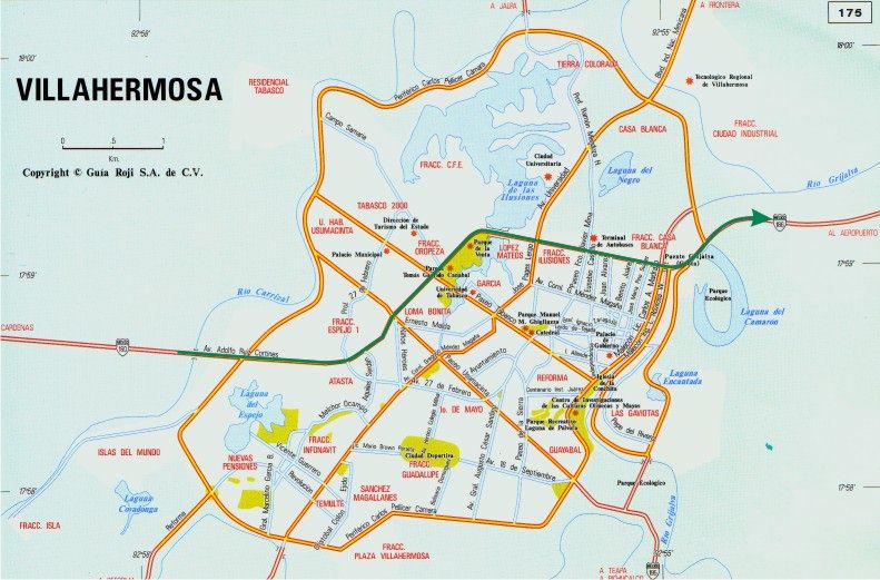
MINATITLAN TO MERIDA After turning right out of the hotel, continue along the same street out of town until you reach and take the exit to the toll road, heading east toward Villahermosa. This leg of the trip is fairly straightforward and there are two options for getting to Merida. I refer to them as the inland route and the coastal route. (Peter and Linda also describe a second coastal route which I have added.) All have their benefits. Traditionally we had always taken the inland route but, due to massive flooding in Tabasco in the fall of 2007, we were forced to take the coastal route. The police and military had roadblocks up to prevent anyone from entering Villahermosa since it was literally underwater. I'll try to describe all routes so that you can make a choice. In my opinion the inland route is somewhat faster than the coastal route, with fewer topes overall, but it is not quite as picturesque. The coastal route allows you to see the gulf for many, many miles along the way to Champoton. Inland Route When taking the inland route you continue on the toll road into and straight through the city of Villahermosa. It is a very spread out city and seems to take forever to go through but it is really an easy city to get through, since the route you will be taking does not involve any turns within the city. In the downtown area the main highway is raised, with collector lanes on both sides, but at a lower level. Stay on the center raised road and you will be fine. Just follow your nose and you will end up at the east end of the city and will almost automatically be guided onto Hwy 186, which is 4 lanes for several miles before becoming a decent 2 lane highway.
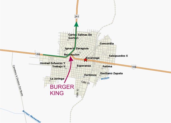
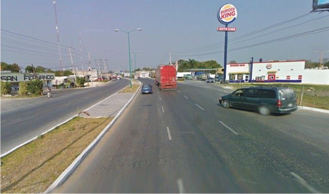
Once you are through Villahermosa it is an easy flat drive to the next main town of Escarcega. Be aware that as you enter and leave Escarcega, the local government felt a need to install a LOT of small but effective topes at each end of town. Just when you think it is safe to speed up DON'T. At the main intersection in town you will be taking Hwy 261 north to Champoton. Also at the main intersection there is a Burger King if you feel a need for some "fast food". If you don't stop, just pass by leaving Burger King on you right. There isn't a real turn involved in Escarcega just follow the main road through a couple of a long sweeping curves to the left.
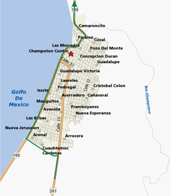
This section of the drive is a bit hilly but quite picturesque and the 2 lane road is in great shape. As you approach Champoton you will need to make a left towards the coast. There are a couple of opportunities to do this, but the way I remember which street to take is that at the outskirts of town the 2 lane highway becomes a divided 4 lane street with a center median. Turn left at the intersection, with a statue in the center of a traffic circle where the median begins. Once you arrive at the coast road turn right and follow it through town.If you miss the original turn, you can continue on Calle 10 and then turn left at Calle 33 as shown, however that route takes you through some narrow streets in the heart of town.
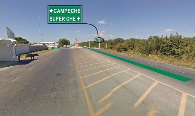
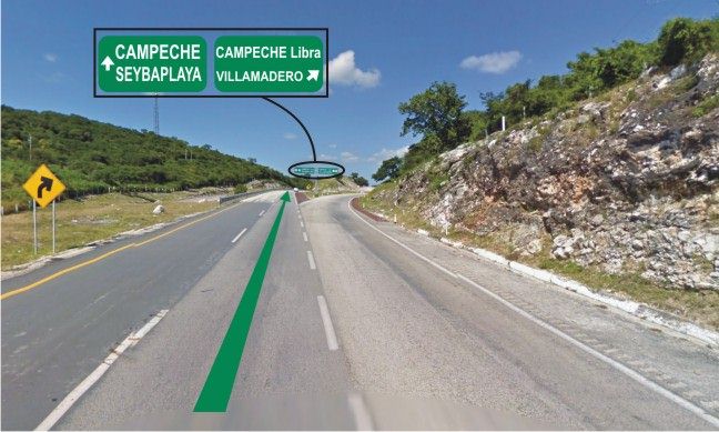
Once you are out of Champoton you will have the option to take the cuota road to Campeche. Take it. This highway will get you to Campeche very quickly and will also take you to the by-pass around Campeche. Just follow the signs to Merida.
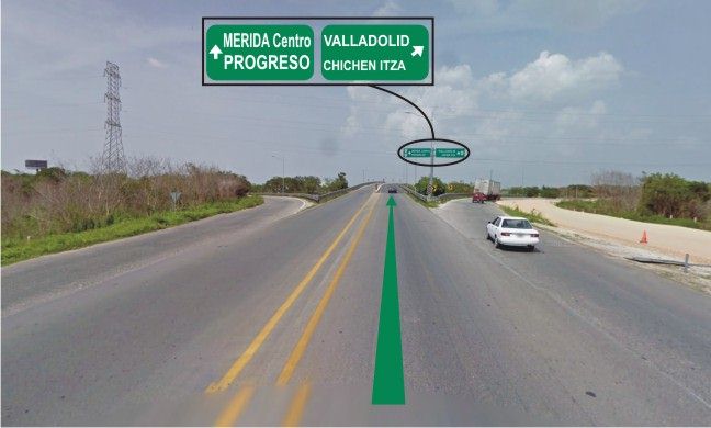
After you have passed by Campeche the roads are very good, but the main highway, 180 intertwines with the secondary roads, which lead to small villages, so you have to make sure you stay on 180. It isn't difficult to stay on route, but just keep your eyes on the directional signs. Once you enter the state of Yucatan you will be on some of the best roads in the entire country. As you approach Merida there is a "periferico" road that circles the city. Depending on where you are going, exit the periferico at the correct exit. Road signs on the periferico are plentiful and very accurate.
For those heading on to Progreso, just continue on the periferico until you see the Progreso exit. It is on the far side of an overpass at the north end of Merida.
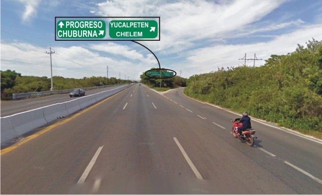
Hwy 261 takes you from Merida to Progreso. It is a brand new 8 lane highway for most of the way to Progreso. If you are heading to Yucalpeten, Chelem or Chuburna there is a by-pass road that takes you directly there instead of going via Progreso. This is the point at which to decide.
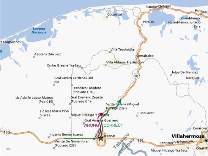
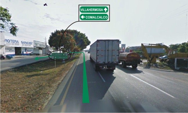
Coastal Route When taking the coastal route, follow the cuota road from Minatitlan towards Villahermosa. About 100 km after leaving Minatitlan there is a city called Cardenas. This is where you will want to turn north to go to Paraiso on Hwy 187. Beware though, there are two Hwy 187's. One is a small road that goes through MANY villages. The one you want is the main and direct Hwy 187 to Paraiso by way of Comalcalco. The small version is the first one you will see, (There is a Pemex station on the right immediately before the wrong road) pass it by and about 4 or 5 kms there will be another exit for 187 north to Paraiso. The last time we took this route we had to pass by 187 and about a couple of KM's later we made a left turn at a retorno and went back to turn right onto 187.( see the picture below for that retorno) If you do end up on the wrong Hwy 187, don't worry. Just grin and bear the topes and then take the first available right turn and you will end up at the intersection where you can turn left to get on the right road.
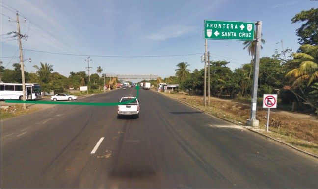
187 is quite a good road and fairly fast. When you have travelled all the way through Paraiso you will make a right turn to head towards Ciudad del Carmen. This is when the going gets slow for a few kilometers. There are many small villages on this narrow 2 lane highway and most of them have a love affair with topes. Be patient, follow a local, watch his brake lights and he will be the best guide through the maze of topes!!! Eventually you will reach a T intersection that is the junction of Hwy 180. Make a left turn here and head to Frontera and Ciudad del Carmen. (Google Street View didn't cover the road from Paraiso to this intersection, but once you arrive at this intersection where the bus is in the picture below just turn left as indicated) Hwy 180 is quite nice and you will be on great roads with few topes from this point on.
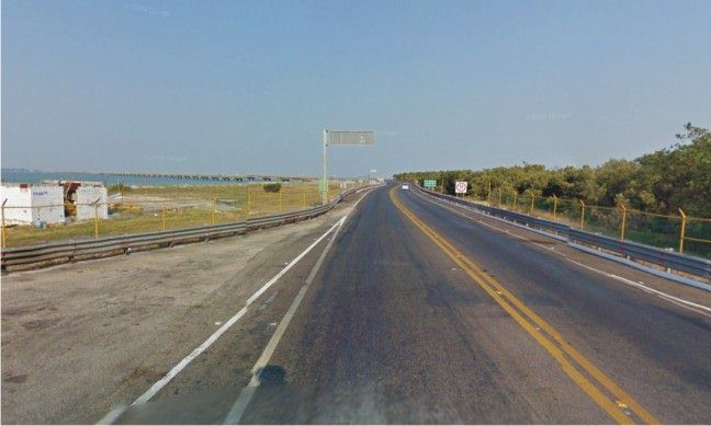
As you approach Ciudad del Carmen there is a very long toll bridge that takes you across a wide inlet.
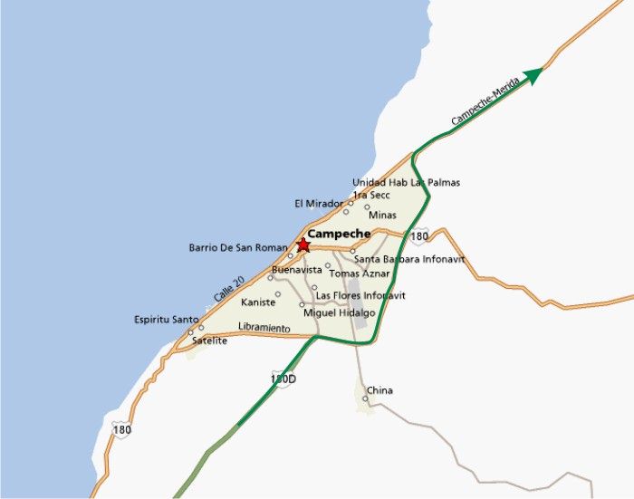
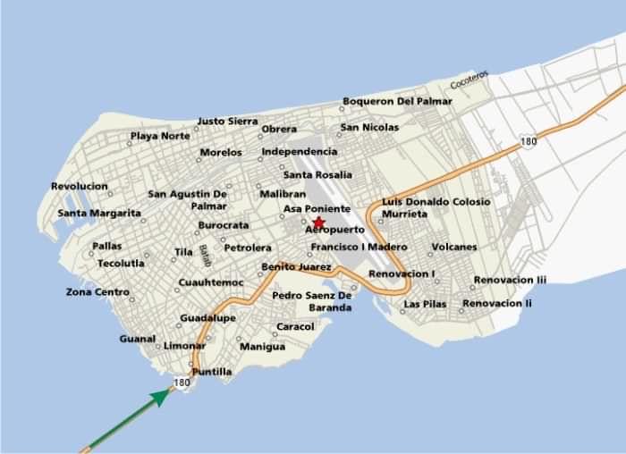
We haven't stopped in Ciudad del Carmen but it looks like it could be an interesting place to explore. Just follow the signs through town to head to Champoton and Campeche. There are a few twists and turns in town, as you can see in the map below, but if you keep your eyes on the signs and follow the general flow of traffic you will have no problems. It is not a huge city, so even if you make a wrong turn you will have no problem getting back on track.
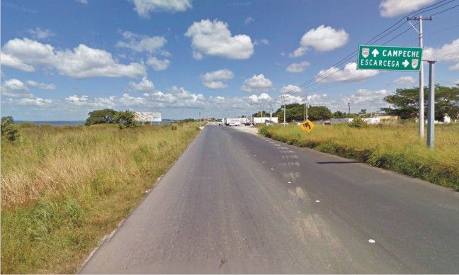
Once through Ciudad del Carmen you will be treated to a newly paved highway with some spectacular views of the gulf and beaches. Continue along the coast until you reach Champoton and just drive straight through town on the street that hugs the shore. The picture below shows the south entrance to Champoton. The intersection shown is where you would have arrived if you had taken the inland route. (where the trucks are turning in the picture)
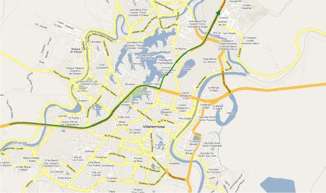
Once through Champoton, refer back to the inland route instructions to continue to Campeche and Merida and Progreso. Below is the description of the route Peter and Linda use to get into Villahermosa and then up to Frontera on the coast. I have added a map of their route though Villahermosa. I always take the Frontera road from Villahermosa. Basically I followed the main drag into the middle of the city and headed north on Avenue Universidad. I took this route because getting into Villahermosa is dead easy and traffic moves very well. I saw no reason to cut north before hitting the city and taking smaller coastal roads and also no reason to go through the city inland to small towns when I could enjoy great scenery along the gulf coast. I found getting through Villahermosa itself to be quick. The approach to the city from the west is very built up with a lot of businesses on either side, but traffic moves very nicely and there are no traffic lights. To get into the city proper you come up over a bridge and it drops you into the city itself. Once over the bridge the road forks going right puts you on the feeder road that parallels the main through road traffic on this feeder road is a mess. So stay left/straight. The main through road has a lot of entry exit points from the right and traffic can get jammed up so drive carefully. If you want to go through the city the safest is to stay in the left lane and avoid the feeder exit/entry points. The beauty of Villahermosa is that the exits dont appear to be signposted. I guess the locals know where they need to go. So you are pretty much driving by a wing and a prayer. To get to the exit I took (Avenue Universidad) it is best to stay in the right lane and grin and bear the traffic because you might miss it otherwise. Once past the fork it is not far to the Avenue Universidad exit. The easiest way to describe the exit is that you will see what looks to be green space/parkland on your right side. This means that the exit is approaching. The next key is you go over a bridge with water beneath. Take the immediate next right and get in the left lane. There is a traffic light at the bottom of the exit. Turn left and go under the main drag. Ignore the sign at the traffic light that tells you Frontera is straight ahead and not to your left. Once you have made the left turn just keep going. After about 2 miles you will see a steep bridge in front of you. Go over this bridge and keep going. Traffic at this bridge can get a bit congested, so be careful. The road soon opens up into 3 lanes each way and pretty soon you are out of the city and on your way to Frontera. If, heaven forbid, you get totally messed up in Villahermosa and miss the turn have no fear continue on straight through the city. You will go over a small, but impressive, river bridge. The road curves to the left. Just around the curve is a massive traffic circle. If you stay to the right you will continue on the main road to the east and past the airport. If you stay left then at the far end of the traffic circle you get 2 options. The first exit takes you back into town, the second swings you left on the Perifico road which is what you want (I recollect that there may have been a sign saying Perifico). This perimeter road swings back over another river bridge and meets up with the Frontera road right at the steep bridge described in the previous paragraph. Once out of the city you can make really good time on the road. 60 mph is quite easy. Villahermosa to Merida is about 340 miles. There are hardly any towns and traffic is light. The towns are well signposted and its a very easy shot to Merida in about 5 ½ hours. You hit the following towns Frontera (Pemex), Atasta, Ciudad Del Carmen (Pemex), Isla Aguada (Pemex), Champoton (Pemex) then the Campeche bypass. Atasta is a very interesting town. It is very long and narrow about 12 KMs. Its claim to fame is that it has 34 topes. So be careful.
Hopefully these directions, maps, diagrams and pictures will be of help to first time drivers through Mexico. If you see any errors or ommisions please feel free to contact me with your comments at. dave@davegrundy.ca
|